


How did the Pine River Dam shape the Whitefish Chain?
The dam at Crosslake controls the outlet on the Pine River. Its construction changed water levels and the connections used by people traveling the lakes. The historic map and dam photograph help put that change in context.

Before it was the Chain we know
An early map and a photograph of the dam tell two different parts of the story that joins the lakes at Crosslake.
At the outlet in Crosslake, the lakes have somewhere to go. Water leaves the Chain and continues down the Pine River. You can take that in on an ordinary walk, even if you have spent years coming up to the same dock. The view invites a question that does not come up very often while passing through a channel on a summer afternoon. How much of this country would a visitor from the middle of the nineteenth century recognize? The Pine River gives us a starting point. A map made before the reservoir and a photograph taken as the new dam was taking shape offer two ways to look back.

Look at the river before the resort maps
At Crosslake you can still stand near the outlet and see the Pine River carry water away from the lakes. Nicollet's nineteenth-century map gives a wider view of the region before the reservoir. Read it alongside the modern lake map and notice how the river still makes sense of places we now know by their separate lake names. The historical map belongs beside the story. Use current charts for navigation.
The dam changed the shoreline
The Army Corps built the original timber dam in the nineteenth century as part of the Mississippi headwaters reservoir system. The Historic American Engineering Record dates construction to 1884-1886 and the concrete reconstruction to 1905-1907. Holding back water changed the local shoreline and helped create permanent connections between lakes that had been separate. Connections changed in later years, too. The DNR's Arrowhead Lake study records a connection dredged in 1961 for fish passage. The modern map carries both histories.
Go see where the water leaves
Visit the Cross Lake Recreation Area and then walk to the village if tours are running. The working dam explains how the system still functions. The History & Stories collection brings the people and businesses back into the picture, from the mailboat to resorts that welcomed families season after season.
Start with the lines on the old map
Joseph Nicollet's 1843 map covers the upper Mississippi basin. Look for the Pine River and Whitefish Lake in a landscape shown at regional scale. A map like this helps you see how water related to the places around it before anyone could pull up a local road map on a phone. It gives the river a prominence that is easy to miss when the first thing you look for today is a town or a highway. The places in between the labels matter. Water, wetlands and travel routes made up a connected country long before a dam stood at Crosslake.
Spend a few minutes with the map before trying to match every line to the present. Its scale and purpose limit what it can tell you about the precise shape of a bay or a narrow piece of shore. Its age is part of its value. It shows the region as it was understood before the headwaters reservoir system reshaped parts of the landscape. It also reminds us that the Chain's history extends far beyond the first resorts. The DNR's regional accounts discuss Dakota and Ojibwe history before commercial logging. A map from one period can direct our attention to an older place without telling every story of the people who lived there.
A dam built here served people far downstream
The headwaters reservoir system stored water to support navigation farther down the Mississippi. At Cross Lake, the Pine River outlet was the place to control water leaving this part of the watershed. Read the Historic American Engineering Record with that larger purpose in mind. The timber work of the 1880s and early twentieth-century concrete reconstruction tell the story of a working structure that had to function long after the first construction crews left. The local consequences were as easy to see on the shore as the downstream purpose was hard to see from Crosslake.
Higher water changed which places were joined and which stretches of ground lay above the lake. To imagine that change, picture the ground that separates two shallow pieces of water. A relatively modest difference in level can change how long a channel stays open and how easy it is to pass between lakes. The difference also shows up in where people can land, which routes they choose and what they call an island. Read the Army Corps dates as dates for the structure and the DNR records as evidence about particular lakes and channels. Together they explain more than one set of records can by itself.
Look closely at what the photograph records
The 1906 photograph is an image of the Pine River Dam in the period of reconstruction. It is worth pausing over the structures along the water and the scale of the work. A modern view gives you the result of generations of maintenance and changes; the photograph gives you one day in the life of the site. The fact that both are views of the same place is enough reason to take the old picture with you when you visit. Stand where the public can see the outlet and try matching the water and its surroundings before trying to identify an exact camera position.
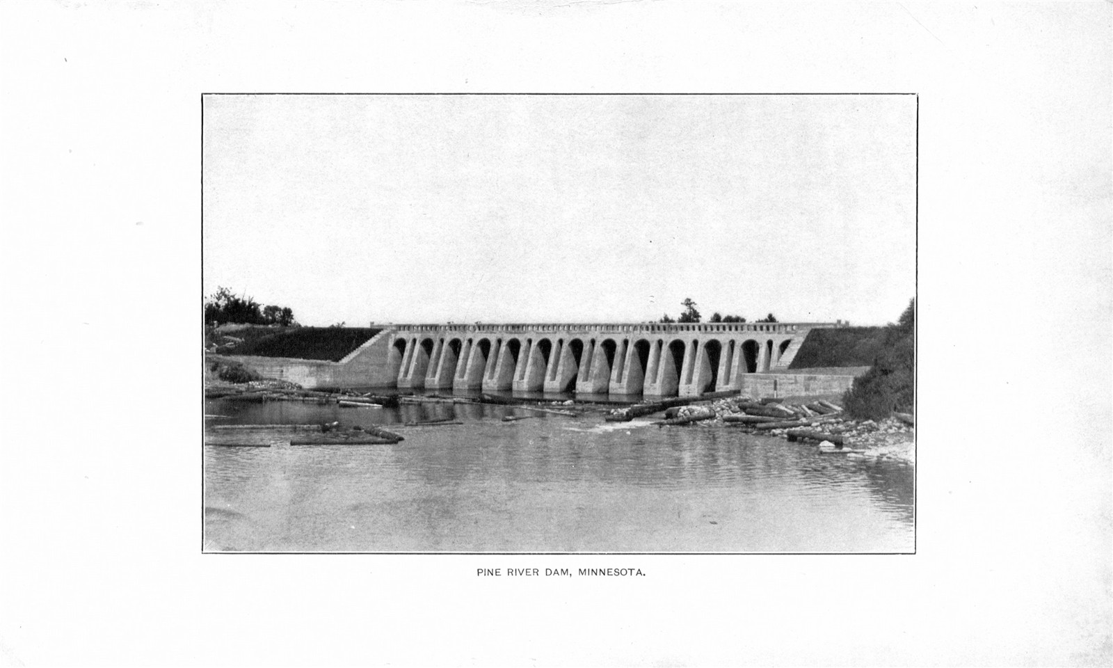
A second useful comparison is with the official record of the Arrowhead Lake connection, made much later. Visitors often talk about the joined waters as if all of the passages came into being in one year. The DNR observed the later dredging of a permanent connection for fish passage. It is an excellent reminder to read a lake's own record before telling its story. Some changes belong to a dam project. Others belong to work on a particular lake and deserve their own place in the chronology.
How the water became the way to get there
A connection on a map changes what an ordinary household can do. If you have a place on one shore and people you need to see on another, the route by water can be the familiar one. In the logging years the region's waters served work as well as travel. In later years a mailboat made regular visits to households on several of the lakes. The idea sounds quaint until you put yourself at one of those docks waiting for something important from town. The boat represents a practical route through a community that was organized around the water. The Whitefish Chain mailboat story follows that part of the history through an actual boat preserved at Crosslake.
Resorts and cabins gave a new generation reasons to learn the passages. Someone staying on the Chain today may come for the same route between lakes year after year. Ask longtime visitors what tells them they are nearly back to their own shore. The answer could be a point, an island or the moment they leave one stretch of water for another. Those small landmarks carry personal histories the engineering record cannot supply. They help explain why the shape of the Chain matters as much as the names on a map.
Spend an hour where the stories meet
For a first visit, start at the Cross Lake Recreation Area and see the outlet from an open public spot. Look upstream and downstream and make sure you can picture which direction the river takes. Take a copy of the old map if you want to compare it with a modern one later. When the Log Village is open, cross to the historical society's side of the road and see which parts of the story you can find there. A brief visit works, but give yourself a little time to look closely at one map or one photograph if you can.
The next time you take a boat across the Chain, the route may look a little different. An opening between lakes becomes a place with a history. Going through it can be a moment to notice how water and work made that particular trip possible, and how much of the landscape still belongs to the river you can see leaving Crosslake.